内容概览
1.openlayers6结合geoserver利用WFS服务实现图层编辑功能
2.源代码demo下载
效果图如下: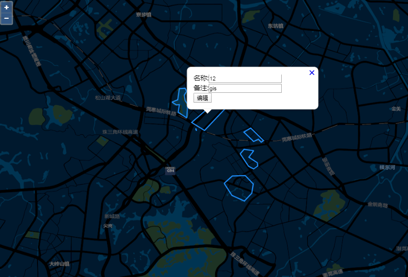
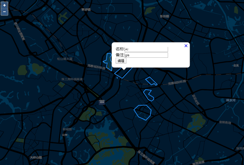
本篇主要是参照openlayers6结合geoserver利用WFS服务实现图层新增功能(附源码下载)基础上实现的,openlayers6通过调用geoserver发布的地图服务WFS来达到图层编辑记录的目的。与GeoServer的WFS进行基于Rest交互关键就在于请求参数,值得注意的是这些请求最好采用POST方法发送。查询可以采用json,但增加,删除,修改都只能采用XML形式Transaction
- 部分核心代码,完整的见源码demo下载
//叠加geoserver发布的wms图层
var geoserverUrl = 'http://localhost:8080/geoserver/WebGIS';
var wmsSource = new TileWMS({
url: geoserverUrl+'/wms',
params: {'LAYERS': 'WebGIS:testLayer', 'TILED': true},
serverType: 'geoserver',
crossOrigin: 'anonymous'
});

var wmsLayer = new TileLayer({
source: wmsSource
});


var view = new View({
projection: 'EPSG:4326',
//center: [0, 0],
//zoom: 2
center: [113.90271877, 22.95186415],
zoom: 13
})

var map = new Map({
target: 'map',
layers: [
new TileLayer({
source: new XYZ({
//url: 'https://{a-c}.tile.openstreetmap.org/{z}/{x}/{y}.png'
url: 'http://cache1.arcgisonline.cn/arcgis/rest/services/ChinaOnlineStreetPurplishBlue/MapServer/tile/{z}/{y}/{x}'
})
}),
wmsLayer
],
overlays: [overlay],
view: view
});

//监听地图鼠标事件
map.on('singleclick',function(e) {
if (e.dragging) {
return;
}
var feature =map.forEachFeatureAtPixel(e.pixel,
function(feature) {
return feature;
});
//console.log('feature',feature);
//console.log('e',e);

if(feature==undefined){
//隐藏气泡窗口
overlay.setPosition(undefined);
closer.blur();
}
var viewResolution = /** @type {number} */ (view.getResolution());
var url = wmsSource.getFeatureInfoUrl(
e.coordinate, viewResolution, 'EPSG:4326',
{'INFO_FORMAT': 'application/json'});
if (url) {
fetch(url)
.then(function (response) { return response.json(); })
.then(function (json) {
//document.getElementById('info').innerHTML = html;
console.log('json',json);
var coordinate = e.coordinate;
if(json.features.length>0){
var properties = json.features[0].properties;
var id = json.features[0].id;
var geometry = json.features[0].geometry;
//var elements = '名称:'+properties.estate_num+'</br>备注:'+properties.holder_nam+'</br><button type="button" id="editBtn">编辑</button>';
var elements = '<span>名称:</span><input type="text" id="estate_num" value = "'+properties.estate_num+'" /></br><span>备注:</span><input type="text" id="holder_nam" value = "'+properties.holder_nam+'" /></br><button type="button" id="editBtn">编辑</button>';
content.innerHTML = elements;
overlay.setPosition(coordinate);
$("#editBtn").unbind("click");
$("#editBtn").click(function(){
//console.log('编辑按钮点击事件');
if(id)
{
//构造polygon
var polygon = '';
var data = geometry.coordinates[0][0];
for(var i=0;i<data.length;i++){
var item = data[i];
polygon += item[0] + ',' + item[1] + ' ' ;
}
polygon += data[0][0] + ',' + data[0][1];
//只编辑属性信息,默认图形信息不变,感兴趣的,读者你们可自行编辑图形变化信息,这里预留图形参数传值了的
editLayers(id,polygon,$("#estate_num").val(),$("#holder_nam").val(),callbackEditLayersWFSService);
}
});
}
});
}

})

/*图层编辑
*@method editLayers
*@param polygon 图形
*@param fid 记录fid值
*@param fieldValue1 字段1值
*@param fieldValue2 字段2值
*@return callback
*/
function editLayers(fid,polygon,fieldValue1,fieldValue2, callback){
var xml = '<wfs:Transaction service="WFS" version="1.0.0" xmlns:opengis="http://webgis.com" xmlns:wfs="http://www.opengis.net/wfs" xmlns:ogc="http://www.opengis.net/ogc" xmlns:gml="http://www.opengis.net/gml" xmlns:xsi="http://www.w3.org/2001/XMLSchema-instance" xsi:schemaLocation="http://www.opengis.net/wfs http://schemas.opengis.net/wfs/1.0.0/WFS-basic.xsd">';
xml += '<wfs:Update typeName="WebGIS:testLayer">';
xml += '<wfs:Property>';
xml += '<wfs:Name>the_geom</wfs:Name>';
xml += '<wfs:Value>';
xml += '<gml:LineString>';
xml += '<gml:coordinates decimal="." cs="," ts=" ">' + polygon + '</gml:coordinates>';
xml += '</gml:LineString>';
xml += '</wfs:Value>';
xml += '</wfs:Property>';
xml += '<wfs:Property>';
xml += '<wfs:Name>estate_num</wfs:Name>';
xml += '<wfs:Value>' + fieldValue1 + '</wfs:Value>';
xml += '</wfs:Property>';
xml += '<wfs:Property>';
xml += '<wfs:Name>holder_nam</wfs:Name>';
xml += '<wfs:Value>' + fieldValue2 + '</wfs:Value>';
xml += '</wfs:Property>';
xml += '<ogc:Filter>';
xml += '<ogc:FeatureId fid="' + fid + '"/>';
xml += '</ogc:Filter>';
xml += '</wfs:Update>';
xml += ' </wfs:Transaction>';


$.ajax({
url: geoserverUrl+'/wfs',
async: true,
data:xml,
type:'Post',
contentType: 'text/xml',
success(result) {
callback(result);
},
error(err) {
console.log(err);
}
})
}
/*
* 图层编辑回调函数
*/
function callbackEditLayersWFSService(data){
console.log('data',data);
//刷新图层
clearMap();
wmsSource.refresh();
}

function clearMap(){
//隐藏气泡窗口
overlay.setPosition(undefined);
closer.blur();
}
几点说明:
1.WebGIS,geoserver工作区;
2.testLayer,操作图层名称;
3.fid,操作图层的默认固有属性字段。
4.estate_num,holder_nam,操作图层属性字段。
图层编辑回调函数,操作成功或者失败,可以在网页的控制台网络看请求结果