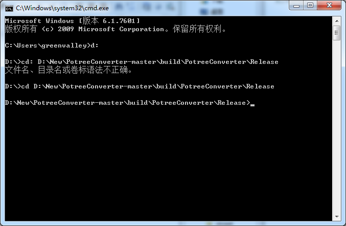
一、打开控制台,进入编译好的文件夹;
potreeConverter的处理命令如下:
-h [ --help ] prints usage
-p [ --generate-page ] arg Generates a ready to use web page with the given name.
-o [ --outdir ] arg output directory
-s [ --spacing ] arg Distance between points at root level. Distance halves each level.
-d [ --spacing-by-diagonal-fraction ] arg Maximum number of points on the diagonal in the first level (sets spacing). spacing = diagonal / value
-l [ --levels ] arg Number of levels that will be generated. 0: only root, 1: root and its children, ...
-f [ --input-format ] arg Input format. xyz: cartesian coordinates as floats, rgb: colors as numbers, i: intensity as number --color-range arg --intensity-range arg
--output-format arg Output format can be BINARY, LAS or LAZ. Default is BINARY
-a [ --output-attributes ] arg can be any combination of RGB, INTENSITY, CLASSIFICATION and NORMAL. Default is RGB.
--scale arg Scale of the X, Y, Z coordinate in LAS and LAZ files.
--aabb arg Bounding cube as "minX minY minZ maxX maxY maxZ". If not provided it is automatically computed
--incremental Add new points to existing conversion
--overwrite Replace existing conversion at target directory
--source arg Source file. Can be LAS, LAZ, PTX or PLY
具体的处理方法:
方法一 :# convert data.las and generate web page
. ./PotreeConverter.exe C:/data.las -o C:/potree_converted -p pageName
方法二:# generate compressed LAZ files instead of the default BIN format
. ./PotreeConverter.exe C:/data.las -o C:/potree_converted --output-format LAZ
方法三:# convert all files inside the data directory
./PotreeConverter.exe C:/data -o C:/potree_converted
方法四:# first, convert with custom bounding box and then append new_data.las afterwards.
# points in new_data MUST fit into bounding box!
./PotreeConverter.exe C:/data -o C:/potree_converted -aabb "-0.748 -2.780 2.547 3.899 1.867 7.195"
./PotreeConverter.exe C:/new_data.las -o C:/potree_converted --incremental
方法五:# tell the converter that coordinates are in a UTM zone 10N projection. Also, create output in LAZ format
./PotreeConverter.exe C:/data -o C:/potree_converted -p pageName --projection "+proj=utm +zone=10 +ellps=GRS80 +datum=NAD83 +units=m +no_defs" --overwrite --output-format LAZ
方法六:# using a swiss projection. Use http://spatialreference.org/ to find projections in proj4 format
./PotreeConverter.exe C:/data -o C:/potree_converted -p pageName --projection "+proj=somerc +lat_0=46.95240555555556 +lon_0=7.439583333333333 +k_0=1 +x_0=600000 +y_0=200000 +ellps=bessel +towgs84=674.4,15.1,405.3,0,0,0,0 +units=m +no_defs" --overwrite

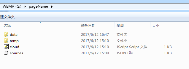
处理结果如下: