这段时间我一直在研究如何用PIE创建带压缩的栅格数据集,由于我在比赛中使用的原始影像大小普遍都在300M以上,软件加载较慢,因此希望能对原始影像进行压缩,加快加载时间。
首先,该方法的关键是修改DataSource.DatasetFactory.CreateRasterDataset()方法中的一个参数。CreateRasterDataset()方法的参数说明请参考《PIESDK For Donet V5.0二次开发指南》。
由于《PIESDK For Donet V5.0二次开发指南》还没来得及更新,实际开发中CreateRasterDataset()方法最后还存在一个指南中未提及的参数mList,这个参数就是用来决定创建的栅格数据集是否是带压缩的。我们只需要将其设置为 "COMPRESS=PACKBITS"即可完成我们的需求。
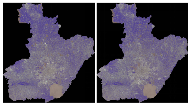
经过对比,两幅影像不存在失真现象(左图为原始影像,右图为压缩后的影像)。
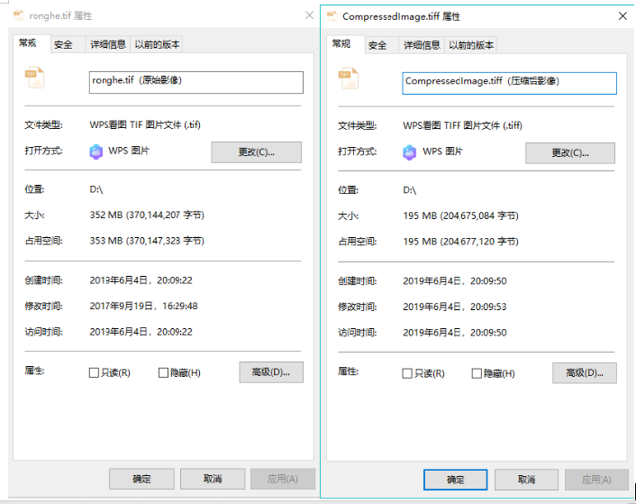
压缩后的大小仅为原影像的一半左右。
源代码如下:
 1 /// <summary>
 2         /// 创建带压缩的栅格数据集事件
 3         /// </summary>
 4         /// <param name="sender"></param>
 5         /// <param name="e"></param>
 6         private void toolStripButton1_Click(object sender, EventArgs e)
 7         {
 8             string pathA = @"D:
onghe.tif";
 9             string[] options = new string[1];
10             options[0] = "COMPRESS=PACKBITS";
11             IRasterDataset rDataset = DatasetFactory.OpenRasterDataset(pathA, OpenMode.ReadOnly);
12             int xSize = rDataset.GetRasterXSize();
13             int ySize = rDataset.GetRasterYSize();
14             int bandCount = rDataset.GetBandCount();
15             IRasterBand rasterband = rDataset.GetRasterBand(bandCount - 1);
16             PixelDataType type = rasterband.GetRasterDataType();
17
18             int[] bandMap = new int[bandCount];
19             for (int i = 0; i < bandCount; i++)
20             {
21                 bandMap[i] = i + 1;
22             }
23
24             double[] geoTransA = rDataset.GetGeoTransform();
25
26             UInt16[] buf = new UInt16[xSize * ySize * bandCount];
27
28             bool ok = rDataset.Read(0,0, xSize, ySize, buf, xSize, ySize, type, bandCount, bandMap);
29
30             ISpatialReference spGLL = rDataset.SpatialReference;
31             string stGLL = spGLL.ExportToWkt();
32
33             string rPathSaveGLL = @"D:CompressedImage.tiff";
34             IRasterDataset rasterDatasetA = DatasetFactory.CreateRasterDataset(rPathSaveGLL, xSize, ySize, bandCount, type, "GTIFF", options);
35
36             rasterDatasetA.Write(0, 0, xSize, ySize, buf, xSize, ySize, type, bandCount, bandMap);
37             rasterDatasetA.SpatialReference = SpatialReferenceFactory.CreateSpatialReference(stGLL);
38             rasterDatasetA.SetGeoTransform(geoTransA);
39             (rasterDatasetA as IDisposable).Dispose();
40
41             mapControlMain.AddLayerFromFile(pathA, 0);
42             mapControlMain.AddLayerFromFile(rPathSaveGLL, 1);
43             mapControlMain.PartialRefresh(ViewDrawPhaseType.ViewAll);
44         }