计算两个经纬度点间的距离
纬度线投射在图上看似水平的平行线,但实际上是不同半径的圆。有相同特定纬度的所有位置都在同一个纬线上。
赤道的纬度为0°,将行星平分为南半球和北半球。
纬度是指某点与地球球心的连线和地球赤道面所成的线面角,其数值在0至90度之间。位于赤道以北的点的纬度叫北纬,记为N,位于赤道以南的点的纬度称南纬,记为S。
纬度数值在0至30度之间的地区称为低纬地区,纬度数值在30至60度之间的地区称为中纬地区,纬度数值在60至90度之间的地区称为高纬地区。
赤道、南回归线、北回归线、南极圈和北极圈是特殊的纬线。
纬度1秒的长度
地球的子午线总长度大约40008km。平均:
纬度1度 = 大约111km
纬度1分 = 大约1.85km
纬度1秒 = 大约30.9m
The haversine formula
在球上任意两个点的距离有如下关系:
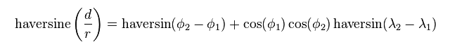

其中,d:两点间距离,既球面距离;
r:球的半径;
 :点1和点2的纬度;
 :点1和点2的经度;


Java版:


 1 import com.google.android.maps.GeoPoint;
 2
 3 public class DistanceCalculator {
 4
 5    private double Radius;
 6
 7    // R = earth's radius (mean radius = 6,371km)
 8    // Constructor
 9    DistanceCalculator(double R) {
10       Radius = R;
11    }
12
13    public double CalculationByDistance(GeoPoint StartP, GeoPoint EndP) {
14       double lat1 = StartP.getLatitudeE6()/1E6;
15       double lat2 = EndP.getLatitudeE6()/1E6;
16       double lon1 = StartP.getLongitudeE6()/1E6;
17       double lon2 = EndP.getLongitudeE6()/1E6;
18       double dLat = Math.toRadians(lat2-lat1);
19       double dLon = Math.toRadians(lon2-lon1);
20       double a = Math.sin(dLat/2) * Math.sin(dLat/2) +
21          Math.cos(Math.toRadians(lat1)) * Math.cos(Math.toRadians(lat2)) *
22          Math.sin(dLon/2) * Math.sin(dLon/2);
23       double c = 2 * Math.asin(Math.sqrt(a));
24       return Radius * c;
25    }
26 }
C#版:
 1 using System;
 2 namespace HaversineFormula
 3 {
 4     /// <summary>
 5     /// The distance type to return the results in.
 6     /// </summary>
 7     public enum DistanceType { Miles, Kilometers };
 8     /// <summary>
 9     /// Specifies a Latitude / Longitude point.
10     /// </summary>
11     public struct Position
12     {
13         public double Latitude;
14         public double Longitude;
15     }
16     class Haversine
17     {
18         /// <summary>
19         /// Returns the distance in miles or kilometers of any two
20         /// latitude / longitude points.
21         /// </summary>
22         /// <param name=”pos1″></param>
23         /// <param name=”pos2″></param>
24         /// <param name=”type”></param>
25         /// <returns></returns>
26         public double Distance(Position pos1, Position pos2, DistanceType type)
27         {
28             double R = (type == DistanceType.Miles) ? 3960 : 6371;
29             double dLat = this.toRadian(pos2.Latitude - pos1.Latitude);
30             double dLon = this.toRadian(pos2.Longitude - pos1.Longitude);
31             double a = Math.Sin(dLat / 2) * Math.Sin(dLat / 2) +
32                 Math.Cos(this.toRadian(pos1.Latitude)) * Math.Cos(this.toRadian(pos2.Latitude)) *
33                 Math.Sin(dLon / 2) * Math.Sin(dLon / 2);
34             double c = 2 * Math.Asin(Math.Min(1, Math.Sqrt(a)));
35             double d = R * c;
36             return d;
37         }
38         /// <summary>
39         /// Convert to Radians.
40         /// </summary>
41         /// <param name="val"></param>
42         /// <returns></returns>
43         private double toRadian(double val)
44         {
45             return (Math.PI / 180) * val;
46         }
47     }
48 }
1 Position pos1 = new Position();
2 pos1.Latitude = 40.7486;
3 pos1.Longitude = -73.9864;
4 Position pos2 = new Position();
5 pos2.Latitude = 24.7486;
6 pos2.Longitude = -72.9864;
7 Haversine hv = new Haversine();
8 double result = hv.Distance(pos1, pos2, DistanceType.Kilometers);
JavaScript版:
1 var R = 6371; // km
2 var dLat = (lat2-lat1)*Math.PI/180;
3 var dLon = (lon2-lon1)*Math.PI/180;
4 var a = Math.sin(dLat/2) * Math.sin(dLat/2) +
5         Math.cos(lat1*Math.PI/180) * Math.cos(lat2*Math.PI/180) *
6         Math.sin(dLon/2) * Math.sin(dLon/2);
7 var c = 2 * Math.asin(Math.sqrt(a));
8 var d = R * c;
Python版:
 1 #coding:UTF-8
 2 """
 3   Python implementation of Haversine formula
 4   Copyright (C) <2009>  Bartek Górny <bartek@gorny.edu.pl>
 5
 6   This program is free software: you can redistribute it and/or modify
 7   it under the terms of the GNU General Public License as published by
 8   the Free Software Foundation, either version 3 of the License, or
 9   (at your option) any later version.
10
11   This program is distributed in the hope that it will be useful,
12   but WITHOUT ANY WARRANTY; without even the implied warranty of
13   MERCHANTABILITY or FITNESS FOR A PARTICULAR PURPOSE.  See the
14   GNU General Public License for more details.
15
16   You should have received a copy of the GNU General Public License
17   along with this program.  If not, see <http://www.gnu.org/licenses/>.
18 """
19
20 import math
21
22 def recalculate_coordinate(val,  _as=None):
23   """
24     Accepts a coordinate as a tuple (degree, minutes, seconds)
25     You can give only one of them (e.g. only minutes as a floating point number) and it will be duly
26     recalculated into degrees, minutes and seconds.
27     Return value can be specified as 'deg', 'min' or 'sec'; default return value is a proper coordinate tuple.
28   """
29   deg,  min,  sec = val
30   # pass outstanding values from right to left
31   min = (min or 0) + int(sec) / 60
32   sec = sec % 60
33   deg = (deg or 0) + int(min) / 60
34   min = min % 60
35   # pass decimal part from left to right
36   dfrac,  dint = math.modf(deg)
37   min = min + dfrac * 60
38   deg = dint
39   mfrac,  mint = math.modf(min)
40   sec = sec + mfrac * 60
41   min = mint
42   if _as:
43     sec = sec + min * 60 + deg * 3600
44     if _as == 'sec': return sec
45     if _as == 'min': return sec / 60
46     if _as == 'deg': return sec / 3600
47   return deg,  min,  sec
48
49
50 def points2distance(start,  end):
51   """
52     Calculate distance (in kilometers) between two points given as (long, latt) pairs
53     based on Haversine formula (http://en.wikipedia.org/wiki/Haversine_formula).
54     Implementation inspired by JavaScript implementation from http://www.movable-type.co.uk/scripts/latlong.html
55     Accepts coordinates as tuples (deg, min, sec), but coordinates can be given in any form - e.g.
56     can specify only minutes:
57     (0, 3133.9333, 0)
58     is interpreted as
59     (52.0, 13.0, 55.998000000008687)
60     which, not accidentally, is the lattitude of Warsaw, Poland.
61   """
62   start_long = math.radians(recalculate_coordinate(start[0],  'deg'))
63   start_latt = math.radians(recalculate_coordinate(start[1],  'deg'))
64   end_long = math.radians(recalculate_coordinate(end[0],  'deg'))
65   end_latt = math.radians(recalculate_coordinate(end[1],  'deg'))
66   d_latt = end_latt - start_latt
67   d_long = end_long - start_long
68   a = math.sin(d_latt/2)**2 + math.cos(start_latt) * math.cos(end_latt) * math.sin(d_long/2)**2
69   c = 2 * math.asin(math.sqrt(a))
70   return 6371 * c
71
72
73 if __name__ == '__main__':
74  warsaw = ((21,  0,  30),  (52, 13, 56))
75  cracow = ((19, 56, 18),  (50, 3, 41))
76  print points2distance(warsaw,  cracow)
PHP版:
 1 function getDistance($latitude1, $longitude1, $latitude2, $longitude2) {
 2     $earth_radius = 6371;
 3
 4     $dLat = deg2rad($latitude2 - $latitude1);
 5     $dLon = deg2rad($longitude2 - $longitude1);
 6
 7     $a = sin($dLat/2) * sin($dLat/2) + cos(deg2rad($latitude1)) * cos(deg2rad($latitude2)) * sin($dLon/2) * sin($dLon/2);
 8     $c = 2 * asin(sqrt($a));
 9     $d = $earth_radius * $c;
10
11     return $d;
12 }
 参考地址:
http://www.codecodex.com/wiki/Calculate_distance_between_two_points_on_a_globe
http://en.wikipedia.org/wiki/Haversine_formula