1. 使用飞线,加上飞机的移动,第一眼看过去和前面的 arcline-animation 很类似。
但是内部的代码内容完全不一样。
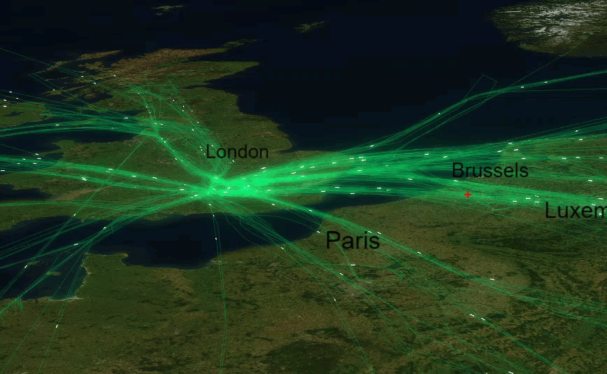
2. 使用了 Bloom 效果,看起来很不错。
3. 材质
 1   var lines = [], lineTrails = [];
 2         var material = new THREE.LineBasicMaterial({
 3             line 1,
 4             color: 'rgb(5,203,87)',
 5             opacity: 0.12,
 6             // blending: THREE.AdditiveBlending,
 7             transparent: true
 8         });
 9         var highlightmaterial = new THREE.LineBasicMaterial({
10             line 1,
11             color: '#fff',
12             opacity: 1,
13             blending: THREE.AdditiveBlending,
14             transparent: true,
15         });
4. LineTrails
 1 class LineTrail extends maptalks.BaseObject {
 2             constructor(lineString, options, material, layer) {
 3                 options = maptalks.Util.extend({}, OPTIONS, options, { layer, lineString });
 4                 super();
 5                 //Initialize internal configuration
 6                 // https://github.com/maptalks/maptalks.three/blob/1e45f5238f500225ada1deb09b8bab18c1b52cf2/src/BaseObject.js#L135
 7                 this._initOptions(options);
 8
 9                 const { altitude, chunkLength, speed, trail } = options;
10                 const chunkLines = lineSlice(lineString, chunkLength);
11
12                 const positions = _getChunkLinesPosition([chunkLines[0]], layer).positions;
13                 const geometry = new THREE.BufferGeometry();
14                 const ps = new Float32Array(MAX_POINTS * 3); // 3 vertices per point
15                 geometry.addAttribute('position', new THREE.BufferAttribute(ps, 3).setDynamic(true));
16                 setLineGeometryAttribute(geometry, positions);
17                 this._createLine(geometry, material);
18
19                 //set object3d position
20                 const z = layer.distanceToVector3(altitude, altitude).x;
21                 this.getObject3d().position.z = z;
22
23                 this._params = {
24                     trail: Math.max(1, trail),
25                     index: 0,
26                     len: chunkLines.length,
27                     chunkLines,
28                     layer,
29                     speed: Math.min(1, speed),
30                     idx: 0,
31                     positions: []
32                 };
33                 // this._init();
34             }
35
36
37             _init() {
38                 const { len, chunkLines, layer, trail } = this._params;
39                 for (let i = 0; i < len; i++) {
40                     const result = chunkLines.slice(i, i + trail);
41                     const ps = _getChunkLinesPosition(result, layer).positions;
42                     this._params.positions[i] = ps;
43                 }
44             }
45
46
47             _animation() {
48                 const { index, positions, idx, speed, len, chunkLines, layer, trail } = this._params;
49                 const i = Math.round(index);
50                 if (i > idx) {
51                     this._params.idx++;
52                     let ps = positions[i];
53                     if (!ps) {
54                         const result = chunkLines.slice(i, i + trail);
55                         ps = _getChunkLinesPosition(result, layer).positions;
56                         this._params.positions[i] = ps;
57                     }
58                     setLineGeometryAttribute(this.getObject3d().geometry, ps);
59                     this.getObject3d().geometry.attributes.position.needsUpdate = true;
60                 }
61                 if (index >= len) {
62                     this._params.index = -1;
63                     this._params.idx = -1;
64                 }
65                 this._params.index += speed;
66             }
67         }
5. TextSprite
 1         class TextSprite extends maptalks.BaseObject {
 2             constructor(coordinate, options, layer) {
 3                 options = maptalks.Util.extend({}, OPTIONS2, options, { layer, coordinate });
 4                 super();
 5                 //Initialize internal configuration
 6                 // https://github.com/maptalks/maptalks.three/blob/1e45f5238f500225ada1deb09b8bab18c1b52cf2/src/BaseObject.js#L135
 7                 this._initOptions(options);
 8                 const { altitude, fontSize, color, text } = options;
 9
10
11                 //Initialize internal object3d
12                 // https://github.com/maptalks/maptalks.three/blob/1e45f5238f500225ada1deb09b8bab18c1b52cf2/src/BaseObject.js#L140
13                 this._createGroup();
14                 const textsprite = new THREE_Text2D.SpriteText2D(text, { align: THREE_Text2D.textAlign.center, font: `${fontSize * 2}px Arial`, fillStyle: color, antialias: false });
15                 this.getObject3d().add(textsprite);
16
17                 //set object3d position
18                 const z = layer.distanceToVector3(altitude, altitude).x;
19                 const position = layer.coordinateToVector3(coordinate, z);
20                 this.getObject3d().position.copy(position);
21             }
22
23
24
25             _animation() {
26                 const scale = this.getMap().getScale() / 2000 / 15 * this.getOptions().fontSize;
27                 this.getObject3d().children[0].scale.set(scale, scale, scale);
28             }
29
30
31         }
6. 线路
 1 function addLines() {
 2             fetch('./data/flight-path.txt').then(function (res) {
 3                 return res.text();
 4             }).then(function (geojson) {
 5                 geojson = LZString.decompressFromBase64(geojson);
 6                 geojson = JSON.parse(geojson);
 7                 geojson.forEach(lnglats => {
 8                     const ps = lnglats.map(l => {
 9                         const [lng, lat, height] = l;
10                         const z = threeLayer.distanceToVector3(height, height).x;
11                         return threeLayer.coordinateToVector3([lng, lat], z);
12                     });
13                     const line = new Line(ps, {}, material, threeLayer);
14                     line.getObject3d().layers.enable(1);
15                     lines.push(line);
16                     // console.log(lineSlice(lnglats, 20000));
17                     const lineTrail = new LineTrail(lnglats, { chunkLength: 5000, altitude: 200, trail: 1 }, highlightmaterial, threeLayer);
18                     lineTrail.getObject3d().layers.enable(1);
19                     lineTrails.push(lineTrail);
20
21                     const lineTrail1 = new LineTrail(lnglats.reverse(), { chunkLength: 5000, altitude: 200, trail: 1 }, highlightmaterial, threeLayer);
22                     lineTrail1.getObject3d().layers.enable(1);
23                     lineTrails.push(lineTrail1);
24                 });
25                 threeLayer.addMesh(lines);
26                 threeLayer.addMesh(lineTrails);
27                 initGui();
28                 animation();
29                 addNames();
30             })
31         }
7. 页面显示
8. 源码地址
https://github.com/WhatGIS/maptalkMap/tree/main/threelayer/demo