1. 说明
使用柱状图,并加上了动画效果。
2. 初始化地图
1 var map = new maptalks.Map("map", { 2 center: [120.74088044043242, 30.48913000018203], 3 zoom: 9.478337137999542, 4 pitch: 58.800000000000026, 5 bearing: -36.29999999999973, 6 // bearing: 180, 7 8 centerCross: true, 9 doubleClickZoom: false 10 // baseLayer: new maptalks.TileLayer('tile', { 11 // urlTemplate: 'https://{s}.basemaps.cartocdn.com/dark_all/{z}/{x}/{y}.png', 12 // subdomains: ['a', 'b', 'c', 'd'], 13 // attribution: '© <a href="http://osm.org">OpenStreetMap</a> contributors, © <a href="https://carto.com/">CARTO</a>' 14 // }) 15 });
3. 添加threelayer 图层,并设置环境。
 1  threeLayer.prepareToDraw = function (gl, scene, camera) {
 2             stats = new Stats();
 3             stats.domElement.style.zIndex = 100;
 4             document.getElementById("map").appendChild(stats.domElement);
 5
 6             var light = new THREE.DirectionalLight(0xffffff);
 7             light.position.set(0, -10, 10).normalize();
 8             scene.add(light);
 9
10             scene.add(new THREE.AmbientLight(0xffffff, 0.2));
11
12             // camera.add(new THREE.PointLight(0xffffff, 1));
13
14             addBars(scene);
15         };
16         threeLayer.addTo(map);
4. 添加柱状图
 1         function addBars(scene) {
 2             const minLng = 120,
 3                 maxLng = 121,
 4                 minLat = 30,
 5                 maxLat = 30.9;
 6             const lnglats = [];
 7             const NUM = 25;
 8             const rows = 24,
 9                 cols = 24;
10             const app = (window.app = new App(NUM, NUM));
11             for (let i = 0; i <= cols; i++) {
12                 const lng = ((maxLng - minLng) / cols) * i + minLng;
13                 for (let j = 0; j <= rows; j++) {
14                     const lat = ((maxLat - minLat) / rows) * j + minLat;
15                     const bar = threeLayer.toBar([lng, lat], { height: 40000, radius: 2000, radialSegments: 4, interactive: false }, material);
16                     bar.getObject3d().rotation.z = Math.PI / 4;
17                     bars.push(bar);
18                     app.staggerArray.push({
19                         altitude: 0
20                     });
21                 }
22             }
23             threeLayer.addMesh(bars);
24             app.init();
25             animation();
26         }
5. 设置方柱动画。
 1 class App {
 2             constructor(rows, cols) {
 3                 this.rows = rows;
 4                 this.cols = cols;
 5
 6                 this.randFrom = ["first", "last", "center"];
 7
 8                 this.easing = [
 9                     "linear",
10                     "easeInOutQuad",
11                     "easeInOutCubic",
12                     "easeInOutQuart",
13                     "easeInOutQuint",
14                     "easeInOutSine",
15                     "easeInOutExpo",
16                     "easeInOutCirc",
17                     "easeInOutBack",
18                     "cubicBezier(.5, .05, .1, .3)",
19                     "spring(1, 80, 10, 0)",
20                     "steps(10)"
21                 ];
22                 this.staggerArray = [];
23             }
24
25             init() {
26                 this.beginAnimationLoop();
27             }
28             beginAnimationLoop() {
29                 // random from array
30                 let randFrom = this.randFrom[
31                     Math.floor(Math.random() * this.randFrom.length)
32                 ];
33                 let easingString = this.easing[
34                     Math.floor(Math.random() * this.easing.length)
35                 ];
36
37                 anime({
38                     targets: this.staggerArray,
39                     altitude: [
40                         { value: 100000 * 0.25, duration: 500 },
41                         { value: -(0 * 0.25), duration: 2000 }
42                     ],
43                     delay: anime.stagger(200, {
44                         grid: [this.rows, this.cols],
45                         from: randFrom
46                     }),
47                     easing: easingString,
48                     complete: (anim) => {
49                         this.beginAnimationLoop();
50                     },
51                     update: () => {
52                         for (let i = 0, len = bars.length; i < len; i++) {
53                             bars[i].setAltitude(this.staggerArray[i].altitude);
54                         }
55                     }
56                 });
57             }
58         }
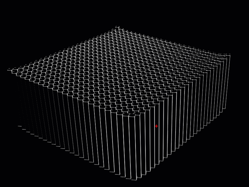
6. 显示效果
7. 源码参考
https://github.com/WhatGIS/maptalkMap