1、前言
在上一篇我们已经我们已经讲述了第一个地图应用程序的HelloMap的创建过程,这一篇我们来讲述基本地图组件:Home Button、比例尺、鹰眼图的使用方法。
2、基本地图组件
在ArcGIS Js API中对于基本的地图组件API都是已经帮我们封装好的,我们一般只需要知道模块怎么调用,摆放在什么位置就可以了。下面我们先贴出HelloMap的基本代码便于后面讲解内容的开展。


<!DOCTYPE html>
<html>
    <head>
        <meta charset="utf-8">
        <title>HelloWord</title>
        <link rel="stylesheet" href="http://js.arcgis.com/3.12/esri/css/esri.css">
        <script src="http://js.arcgis.com/3.12/"></script>
        <script>
              var map ;
              require ([ "esri/map" ,  "dojo/domReady!" ], function ( Map )  {
                 map =  new  Map ( "mapDiv" ,  {
                  center :  [- 56.049 ,  38.485 ],
                  zoom :  3 ,
                  basemap :  "streets"
                });
              });
        </script>
        <style>
            html, body, #mapDiv {
              padding: 0;
              margin: 0;
              height: 100%;    }
        </style>
    </head>
    <body>
        <div id="mapDiv"></div>
    </body>
</html>
2.1、Home Button
Home Button是用于恢复到地图初始化范围的功能组件,基本使用流程如下:
(1)、从API中加载Home Button模块
(2)、在Html页面中创建Home Button模块
(3)、在Js代码创建Home Button事例并绑定到Html页面代码
(4)、设置Home Button 摆放位置
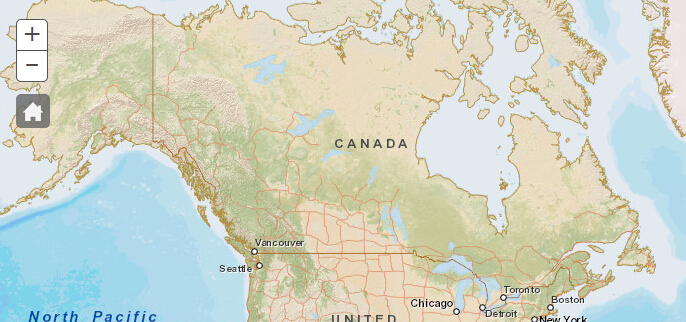
下图中标示部分即为Home Button模块代码。
<!DOCTYPE html>
<html>
    <head>
        <!--<meta charset="utf-8">-->
        <meta http-equiv="Content-Type" content="text/html; charset=utf-8">
        <meta http-equiv="X-UA-Compatible" content="IE=7,IE=9">
        <meta name="viewport" content="initial-scale=1, maximum-scale=1, user-scalable=no">
        <title>HelloWord</title>
        <link rel="stylesheet" href="http://js.arcgis.com/3.12/esri/css/esri.css">
        <script src="http://js.arcgis.com/3.12/"></script>
        <script>
              var map ;
              require ([
                  "esri/map" ,
                  "esri/dijit/HomeButton",
                  "dojo/domReady!"
              ], function (
                  Map ,
                  HomeButton
              ){
                 map =  new  Map ( "mapDiv" ,  {
                  center :  [- 56.049 ,  38.485 ],
                  zoom :  3 ,
                  basemap :  "streets"
                });

                 var home = new HomeButton({
                    map: map
                 }, "HomeButton");
                 home.startup();

              });
        </script>
        <style>
            html, body, #mapDiv {
                  padding: 0;
                  margin: 0;
                  height: 100%;
              }
              #HomeButton {
                position: absolute;
                top: 95px;
                left: 20px;
                z-index: 50;
              }
        </style>
    </head>
    <body>
        <div id="mapDiv">
            <div id="HomeButton"></div>
        </div>
    </body>
</html>
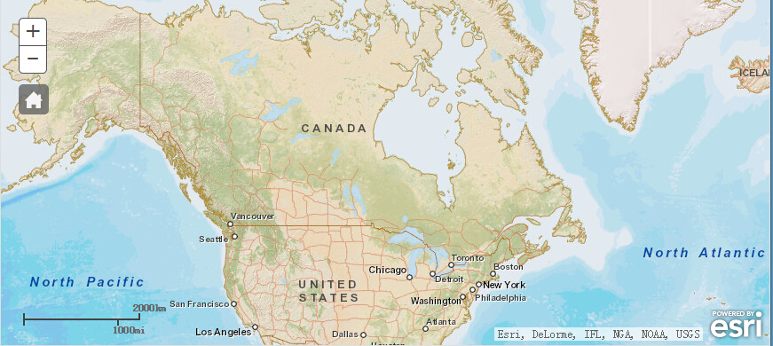
2.2、比例尺
比例尺的使用流程如下:
(1)、从API中加载比例尺模块
(2)、在Js代码创建比例尺并初始化绑定到Map组件
<!DOCTYPE html>
<html>
    <head>
        <!--<meta charset="utf-8">-->
        <meta http-equiv="Content-Type" content="text/html; charset=utf-8">
        <meta http-equiv="X-UA-Compatible" content="IE=7,IE=9">
        <meta name="viewport" content="initial-scale=1, maximum-scale=1, user-scalable=no">
        <title>HelloWord</title>
        <link rel="stylesheet" href="http://js.arcgis.com/3.12/esri/css/esri.css">
        <script src="http://js.arcgis.com/3.12/"></script>
        <script>
              var map ;
              require ([
                  "esri/map" ,
                  "esri/dijit/HomeButton",
                  "esri/dijit/Scalebar",
                  "dojo/domReady!"
              ], function (
                  Map ,
                  HomeButton,
                  Scalebar
              ){
                 map =  new  Map ( "mapDiv" ,  {
                  center :  [- 56.049 ,  38.485 ],
                  zoom :  3 ,
                  basemap :  "streets"
                });

                 var home = new HomeButton({
                    map: map
                 }, "HomeButton");
                 home.startup();

                 var scalebar = new Scalebar({
                      map: map,
                      // "dual" displays both miles and kilmometers
                      // "english" is the default, which displays miles
                      // use "metric" for kilometers
                      scalebarUnit: "dual"
                 });

              });
        </script>
        <style>
            html, body, #mapDiv {
                  padding: 0;
                  margin: 0;
                  height: 100%;
              }
              #HomeButton {
                position: absolute;
                top: 95px;
                left: 20px;
                z-index: 50;
              }
        </style>
    </head>
    <body>
        <div id="mapDiv">
            <div id="HomeButton"></div>
        </div>
    </body>
</html>
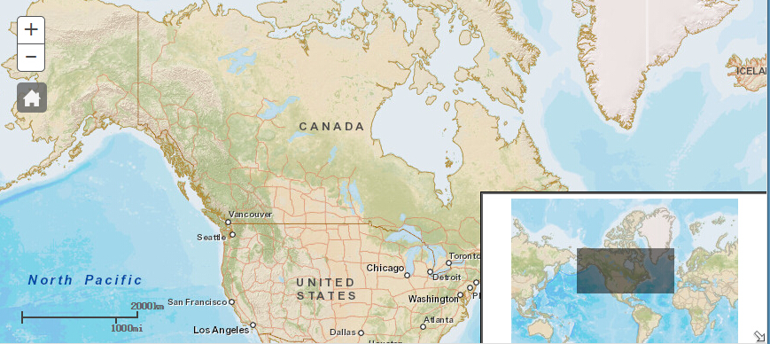
2.3、鹰眼图
鹰眼图是常用地图组件之一,主要用于显示当前可视区域在全局的基本情况,其使用方法同比例尺
(1)、从API中加载鹰眼图模块
(2)、在Js代码创建鹰眼图并初始化绑定到Map组件,attachTo属性为摆放位置信息
<!DOCTYPE html>
<html>
    <head>
        <!--<meta charset="utf-8">-->
        <meta http-equiv="Content-Type" content="text/html; charset=utf-8">
        <meta http-equiv="X-UA-Compatible" content="IE=7,IE=9">
        <meta name="viewport" content="initial-scale=1, maximum-scale=1, user-scalable=no">
        <title>HelloWord</title>
        <link rel="stylesheet" href="http://js.arcgis.com/3.12/esri/css/esri.css">
        <script src="http://js.arcgis.com/3.12/"></script>
        <script>
              var map ;
              require ([
                  "esri/map" ,
                  "esri/dijit/HomeButton",
                  "esri/dijit/Scalebar",
                  "esri/dijit/OverviewMap",
                  "dojo/domReady!"
              ], function (
                  Map ,
                  HomeButton,
                  Scalebar,
                  OverviewMap
              ){
                 map =  new  Map ( "mapDiv" ,  {
                  center :  [- 56.049 ,  38.485 ],
                  zoom :  3 ,
                  basemap :  "streets"
                });

                 var home = new HomeButton({
                    map: map
                 }, "HomeButton");
                 home.startup();

                 var scalebar = new Scalebar({
                      map: map,
                      // "dual" displays both miles and kilmometers
                      // "english" is the default, which displays miles
                      // use "metric" for kilometers
                      scalebarUnit: "dual"
                 });

                 var overviewMapDijit = new OverviewMap({
                      map: map,
                      attachTo: "bottom-right",
                      visible: true
                 });
                 overviewMapDijit.startup();//完成创建鹰眼图
                 overviewMapDijit.hide();//隐藏鹰眼图

              });
        </script>
        <style>
            html, body, #mapDiv {
                  padding: 0;
                  margin: 0;
                  height: 100%;
              }
              #HomeButton {
                position: absolute;
                top: 95px;
                left: 20px;
                z-index: 50;
              }
        </style>
    </head>
    <body>
        <div id="mapDiv">
            <div id="HomeButton"></div>
        </div>
    </body>
</html>
3、参考链接
https://developers.arcgis.com/javascript/jssamples/widget_home.html
https://developers.arcgis.com/javascript/jssamples/widget_scalebar.html
https://developers.arcgis.com/javascript/jssamples/widget_overviewmap.html