今年7月刚刚发布的ArcGIS 10.2为GIS的web开发带来了一个很实在的功能,JSON转要素。以往GIS图层外部数据(如文本数据,数据库数据)动态地写入地图服务中的图层是一件不可想象的事情,如今可以用JSON动态地生成图层中的要素了,在这重新整理分享一个实战经验。
饮水思源,转载勿删:http://www.cnblogs.com/evkchina/p/3478999.html,请支持关注北京易维清www.evkchina.com
首先谈谈需要解决的一个问题,以数据库的形式存了一批点的数据,包括点的经纬度,及相关的信息,如水体的污染物浓度,而且这些点每天都有一套数据,我需要在WEB上根据时间把这些点查询并显示在相应的地图上,不能每天都从数据库中取数做成图层发布一次吧,这会累死不可,这就需要一个自动查询数据库点并动态形成GIS图层加载到的相应的地图上。好,下面就来解决这个问题。
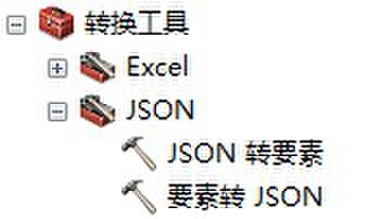
1.创建ArcGIS模型:用转换工具》JSON》JSON转要素,设置JSON文件(PDATA)和输出图层(PointResult.shp)为模型参数,输出图层(PointResult.shp)勾选添加至显示。
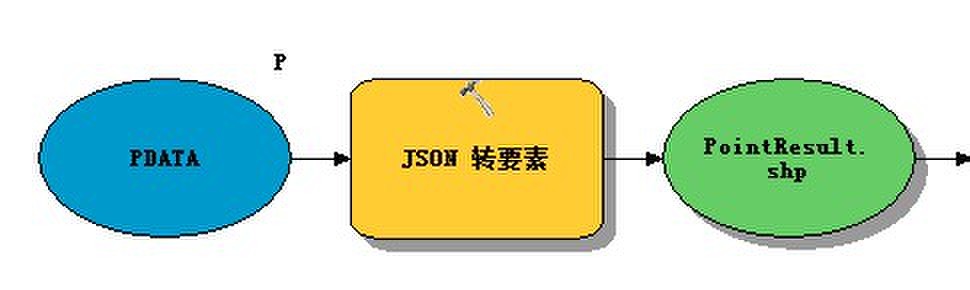
ArcGIS使用的JSON文件是比较复杂的,可以先做一个规范的要素图层然后使用 要素转JSON 工具生成一个JSON,在根据生成的JSON格式,制作动态的JSON数据。
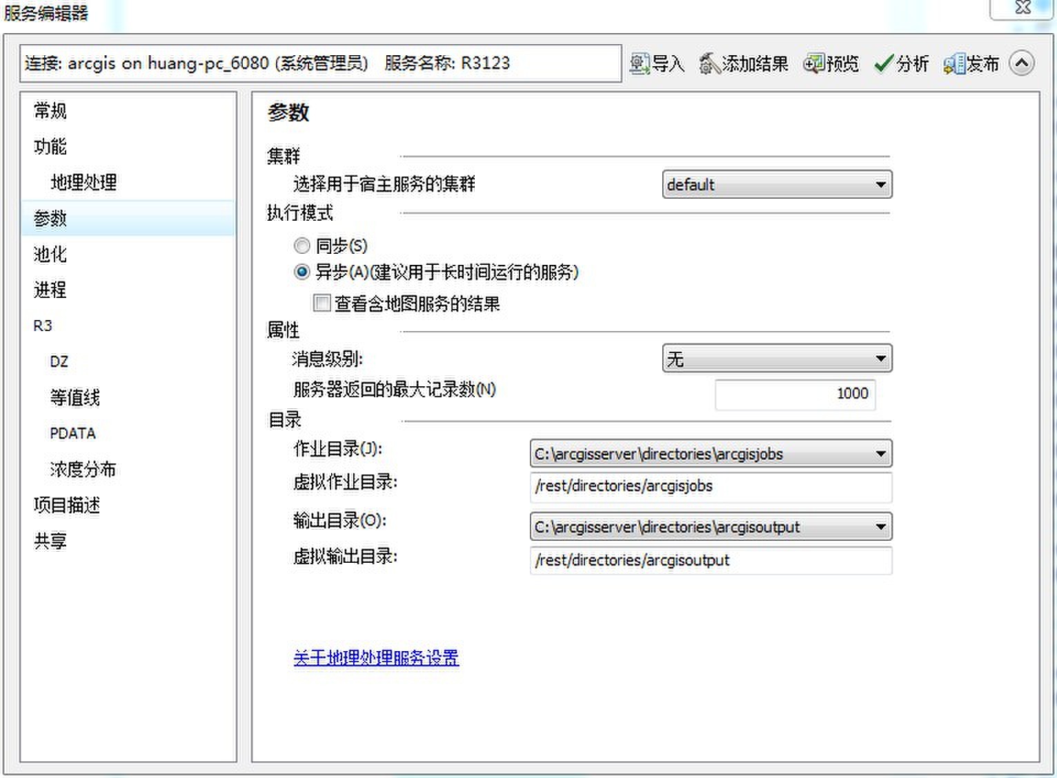
2.把模型发布为地理处理服务:关闭模型编辑编辑窗口,双击运行模型,在结果窗口中把模型运行结果共享为地理处理服务,注意勾选参数》异步》查看含地图服务的结果。
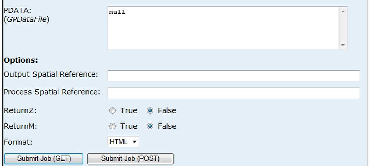
发布完成后,可查看服务的submitJob界面,这里的PDATA(GPDataFile)需要一个JSON文件的路径作为参数,形式为"{'url': 'json文件路径'}"。
3.在Asp.net MVC中使用地理处理服务:View代码(.cshtml)的关键脚本为(由于时间问题没有重新整理,粘贴了之前的代码,代码里有一个DZ的参数,是地理处理服务的另一个参数可以忽略),
可以参照Arcgis官网给出的例子(https://developers.arcgis.com/en/javascript/jssamples/gp_resultmapservice.html),但由于遇到跨域问题,代码改动的比较多。


    <script type="text/javascript">
        require([
          "dojo/dom",
          "dojo/_base/array",
          "dojo/date/locale",
          "dojo/parser",
          "dijit/registry",

          "esri/domUtils",
          "esri/map",
          "esri/graphic",
          "esri/layers/ArcGISDynamicMapServiceLayer",
          "esri/layers/FeatureLayer",
          "esri/tasks/Geoprocessor",
          "esri/dijit/Legend",

          "dijit/form/DateTextBox",
          "dijit/layout/BorderContainer",
          "dijit/layout/ContentPane"],
        function (dom, array, locale, parser, registry,
             domUtils, Map, Graphic, ArcGISDynamicMapServiceLayer, FeatureLayer, Geoprocessor, Legend) {
            var gpServiceUrl = "http://huang-pc:6080/arcgis/rest/services/dianchi/R3/GPServer/R3",
              mapserviceurl = "http://localhost:6080/arcgis/rest/services/dianchi/R3/MapServer/jobs",
              legend;

            parser.parse();

            var map = new Map("map", {
                basemap: "satellite",
                center: [102.7038, 24.8270],
                logo: false,
                zoom: 11
            });

            var dituLayer = new ArcGISDynamicMapServiceLayer("http://huang-pc:6080/arcgis/rest/services/dianchi/ditu/MapServer", {
                "id": "ditu00"
            });
            map.addLayers([dituLayer]);

            function findHotspot() {
                //cleanup any results from previous runs
                cleanup();
                mysubmitJob();
            }

            function cleanup() {
                //hide the legend and remove the existing hotspot layer
                //                domUtils.hide(dom.byId('legendDiv'));
                var hotspotLayer = map.getLayer('HotspotLayer');
                if (hotspotLayer) {
                    map.removeLayer(hotspotLayer);
                }
            }


            var jobs = 0;
            var jobstatus = "";
            var interval;

            function mysubmitJob() {
                var dzdata = $("#dzData").val();
                var thedate = $("#theDate").val();
                var wq = $("#dataType").val();
                var pdata = "{'url': '" + "http://localhost:5907/Home/R3GISViewJSON/" + thedate + "/" + wq + "/JSONTEMP.JSON'}"
                var submitjoburl = gpServiceUrl + "/submitJob";
                $.ajax({
                    type: 'get',
                    dataType: "jsonp",
                    url: submitjoburl,
                    data: { DZ: dzdata, PDATA: pdata, f: "pjson" },
                    jsonpCallback: "jsonpCallback",
                    success: function (data) {
                        jobs = 0;
                        if (data.jobStatus == "esriJobSucceeded") {
                            doMapJob(data);
                        }
                        else {
                            getJobStatus(data.jobId);
                        }
                    }
                });
            }

            function getJobStatus(sjobid) {
                clearTimeout(interval);
                domUtils.show(dom.byId('status'));
                if (jobs < 60) {
                    var sjoburl = gpServiceUrl + "/jobs/" + sjobid;
                    $.ajax({
                        type: "get",
                        dataType: "jsonp",
                        url: sjoburl,
                        data: { f: "pjson" },
                        jsonpCallback: "jsonpCallback",
                        success: function (data) {
                            switch (data.jobStatus) {
                                case 'esriJobSubmitted':
                                    jobstatus = '已提交...';
                                    dom.byId('status').innerHTML = jobstatus;
                                    jobs = jobs + 1;
                                    interval = setTimeout(function () { getJobStatus(data.jobId) }, 1000);
                                    break;
                                case 'esriJobExecuting':
                                    jobstatus = '处理中...';
                                    dom.byId('status').innerHTML = jobstatus;
                                    jobs = jobs + 1;
                                    interval = setTimeout(function () { getJobStatus(data.jobId) }, 1000);
                                    break;
                                case 'esriJobSucceeded':
                                    clearTimeout(interval);
                                    domUtils.hide(dom.byId('status'));
                                    doMapJob(data);
                                    break;
                                case 'esriJobFailed':
                                    clearTimeout(interval);
                                    jobstatus = '查询失败';
                                    dom.byId('status').innerHTML = jobstatus;
                                    gpJobFailed();
                            }
                        }
                    });
                }
                else {
                    clearTimeout(interval);
                    jobstatus = '查询失败';
                    dom.byId('status').innerHTML = jobstatus;
                    gpJobFailed();
                }
            }

            function gpJobFailed() {
                //domUtils.hide(dom.byId('status'));
            }

            function doMapJob(jobinfo) {
                //construct the result map service url using the id from jobinfo we'll add a new layer to the map
                var mapurl = mapserviceurl + "/" + jobinfo.jobId;
                var hotspotLayer = new ArcGISDynamicMapServiceLayer(mapurl, {
                    "id": "HotspotLayer",
                    "opacity": 1
                });

                //add the hotspot layer to the map
                map.addLayers([hotspotLayer]);
                legend = new Legend({
                    map: map
                }, "legendDiv");
                legend.startup();
            }
            app = {
                findHotspot: findHotspot
            };
            return app;
        });
        function hidediv() {
            var ditu00div = $("#legendDiv_ditu00");
            if (ditu00div.html() == "") {
                return;
            }
            $("#legendDiv_ditu00").html("");
            hidediv();
        }
    </script>
生成JSON的Controller代码为:
        public ActionResult R3GISViewLSWQJSON(string dt, string wq)
        {
            var cultureInfo = CultureInfo.CreateSpecificCulture("zh-CN");
            string format = "yyyy-M-d";
            var datetime = System.DateTime.ParseExact(dt, format, cultureInfo);
            var pointjson = new POINTJSON().getjsonfile(datetime, wq, "历史数据");
            JsonResult jsonData = new JsonResult
            {
                Data = pointjson
            };
            return Json(jsonData.Data, "application/json", JsonRequestBehavior.AllowGet);
        }
new POINTJSON().getjsonfile()返回一个JSON结构的类,
JsonResult jsonData = new JsonResult { Data = pointjson };
将类转化为JSON结构数据。
这里有一个很重要的技巧,这是使用Asp.net MVC的一个特点,View代码中 var pdata = "{'url': '" + "http://localhost:5907/Home/R3GISViewLSWQJSON/" + thedate + "/" + wq + "/JSONTEMP.JSON'}" 作为PDATA(GPDataFile)的参数(一个JSON文件的路径"{'url': 'json文件路径'}"),但是这里没有用到临时文件,而是直接输出JSON数据,后面是有一个路由作为支撑的,代码为:
routes.MapRoute(
                "GetJson", // Route name
                "{controller}/{action}/{dt}/{wq}/{json}", // URL with parameters
                new { controller = "Home", action = "Index", dt = UrlParameter.Optional, wq = UrlParameter.Optional, id = UrlParameter.Optional } // Parameter defaults
            );
这里有3个参数,前两个由Controller的方法 public ActionResult R3GISViewLSWQJSON(string dt, string wq) 接收了,而第3个在这个方法里是没有出现的,但是它非常重要,它是用来欺骗ArcGIS服务用的,PDATA(GPDataFile)是一个文件的路径,带.json后缀,这个参数刚好用来.json结尾,让ArcGIS服务当做服务来处理了,省去了临时文件的繁琐工作。
到此为止,问题就结局了。
由于时间关系,很多具体的细节没有在这里说到,请见谅,欢迎在本文评论中交流学习。
饮水思源,转载勿删:http://www.cnblogs.com/evkchina/p/3478999.html,请支持关注北京易维清www.evkchina.com 最后,卖一个关子,就是JSON数据转换成较多的线要素和面要素时,JSON文件特别大,这种方法失效了,所以线要素和面要素的动态数据还得用别的方法,后面会继续跟大家分享,敬请关注。
 |
 |