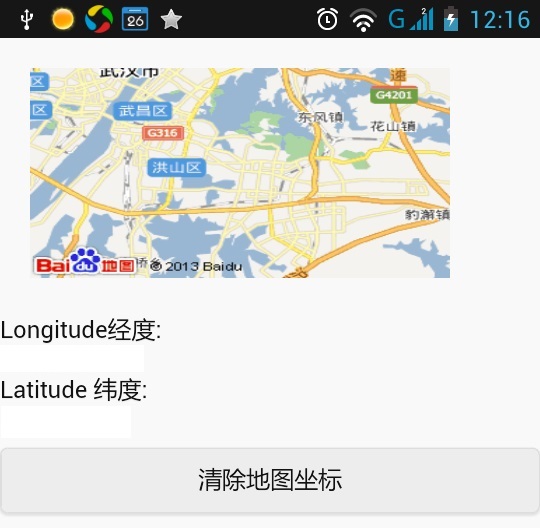
使用Geolocation基于所在地理位置坐标调用百度地图API 效果图
示例代码
<!DOCTYPE html>
<html>
  <head>
    <title>
      PhoneGap Device Ready Example
    </title>
    <link
        href="content/css/themes/default/jquery.mobile.structure-1.4.0-beta.1.min.css"
        rel="stylesheet"
        type="text/css"/>
    <link href="content/css/themes/default/jquery.mobile-1.4.0-beta.1.min.css" rel="stylesheet" type="text/css"/>
    <script src="content/js/jquery.js" type="text/javascript">
    </script>
    <script src="content/js/jquery.mobile-1.4.0-beta.1.js" type="text/javascript">
    </script>
    <script src="content/js/cordova.js" type="text/javascript">
    </script>
    <script src="content/scripts/xui-2.2.0.min.js">
    </script>
    <script src="content/scripts/emile.js">
    </script>
    <script type="text/javascript" charset="utf-8">
      document.addEventListener("deviceready", onDeviceReady, false);
      var watchID = null;
      function onDeviceReady() {
        var options = { frequency: 1333000 };
        watchID =  navigator.geolocation.getCurrentPosition(onSuccess, onError, { maximumAge: 3000, timeout: 10000, enableHighAccuracy: true });
      }

      function onSuccess(position) {
        var element = document.getElementById('geolocation');
        var mapurlstr="<img style="margin:20px" width="280" height="140" src="http://api.map.baidu.com/staticimage?center="+ position.coords.longitude+ ","+position.coords.latitude+"&width=300&height=200&zoom=11" /> ";
        alert(mapurlstr);
        x$('#map').html('inner', mapurlstr);
        x$('#Latitude').html('inner', position.coords.latitude);
        x$('#Longitude').html('inner', position.coords.longitude);
      }

      function onError(error) {
        alert('code: '    + error.code    + '
' +
        'message: ' + error.message + '
');
      }
      // 清除前述已经开始的监视
      function clearWatch() {
        if (watchID != null) {
          navigator.geolocation.clearWatch(watchID);
          watchID = null;
        }
      }
    </script>
    <script>
      function initialise()
      {
        styleshow();
        dom();
        fx();

      }
      //dom处理
      function  dom()
      {
      }
      function SubString(s){
        var str;                // 声明变量。
        str = s.substr(1,236); // 截取取字符串。
        return(str);           // 返回字符串。
      }
      //style  样式处理
      function styleshow()
      {

      }
      //style 动画、形变、渐变
      function fx()
      {

      }
    </script>
  </head>
  <body onload="initialise();">
    <div id="map">
      地图显示区
    </div>

    Longitude经度:
    <div id="Longitude">
      经度:显示区
    </div>
    Latitude 纬度:
    <div id="Latitude">
      纬度显示区
    </div>

    <button onclick="clearWatch();">
      清除地图坐标
    </button>

  </body>
</html>
代码示例包
声明:本博客高度重视知识产权保护,发现本博客发布的信息包含有侵犯其著作权的链接内容时,请联系我,我将第一时间做相应处理,联系邮箱ffgign@qq.com。
作者:Mark Fan (小念头) 来源:http://cube.cnblogs.com
说明:未经作者同意必须保留此段声明,且在文章页面明显位置给出原文连接,否则保留追究法律责任的权利。如有疑问,可以通过 ffgign@qq.com 联系作者,本文章采用 知识共享署名-非商业性使用-相同方式共享 2.5 中国大陆许可协议进行许可
