basemap基于GEOS的地图二维数据,其底图数据库与GMT相同,封装了大量常用的地图投影、坐标转换功能,利用简洁的Python语法支持绘出多种多样的地理地图
1.安装
基于geos的,先安装geos
pip install geos
https://www.lfd.uci.edu/~gohlke/pythonlibs/ 下载
basemap-1.2.2-cp37-cp37m-win_amd64.whl
注:
cp后面的数字是Python的版本,根据自己的python版本来
安装
pip install basemap-1.2.2-cp37-cp37m-win_amd64.whl --default-timeout=200
eg:
绘制最简单的地图
from mpl_toolkits.basemap import Basemap
import matplotlib.pyplot as plt

map = Basemap()

map.drawcoastlines()

plt.show()
plt.savefig('test.png')

可以给陆地和海洋填上不同的颜色
from mpl_toolkits.basemap import Basemap
import matplotlib.pyplot as plt

map = Basemap(projection='ortho',
              lat_0=0, lon_0=0)

#Fill the globe with a blue color
map.drawmapboundary(fill_color='aqua')
#Fill the continents with the land color
map.fillcontinents(color='coral',lake_color='aqua')

map.drawcoastlines()

plt.show()

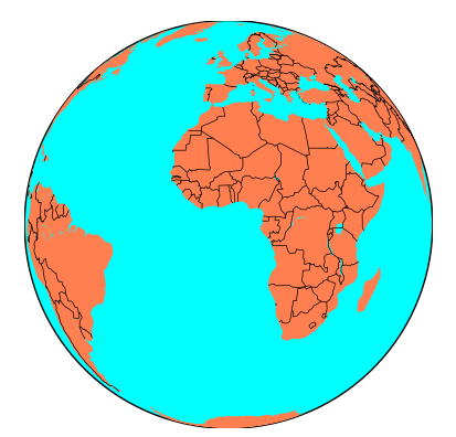
绘制国家边界
from mpl_toolkits.basemap import Basemap
import matplotlib.pyplot as plt

map = Basemap(projection='ortho',
              lat_0=0, lon_0=0)

map.drawmapboundary(fill_color='aqua')
map.fillcontinents(color='coral',lake_color='aqua')

map.drawcountries()

plt.show()
官网
https://basemaptutorial.readthedocs.io/en/latest/first_map.html